BC Adventures
FSR Driving in the Fraser Valley: What You Actually Need to Know Before You Go
Forest Service Roads are not Hwy 1 with gravel on them — they are industrial access roads. What you actually need to know before running BC FSRs out of Chilliwack.
*Posted by Darren Miller | Millervantures*
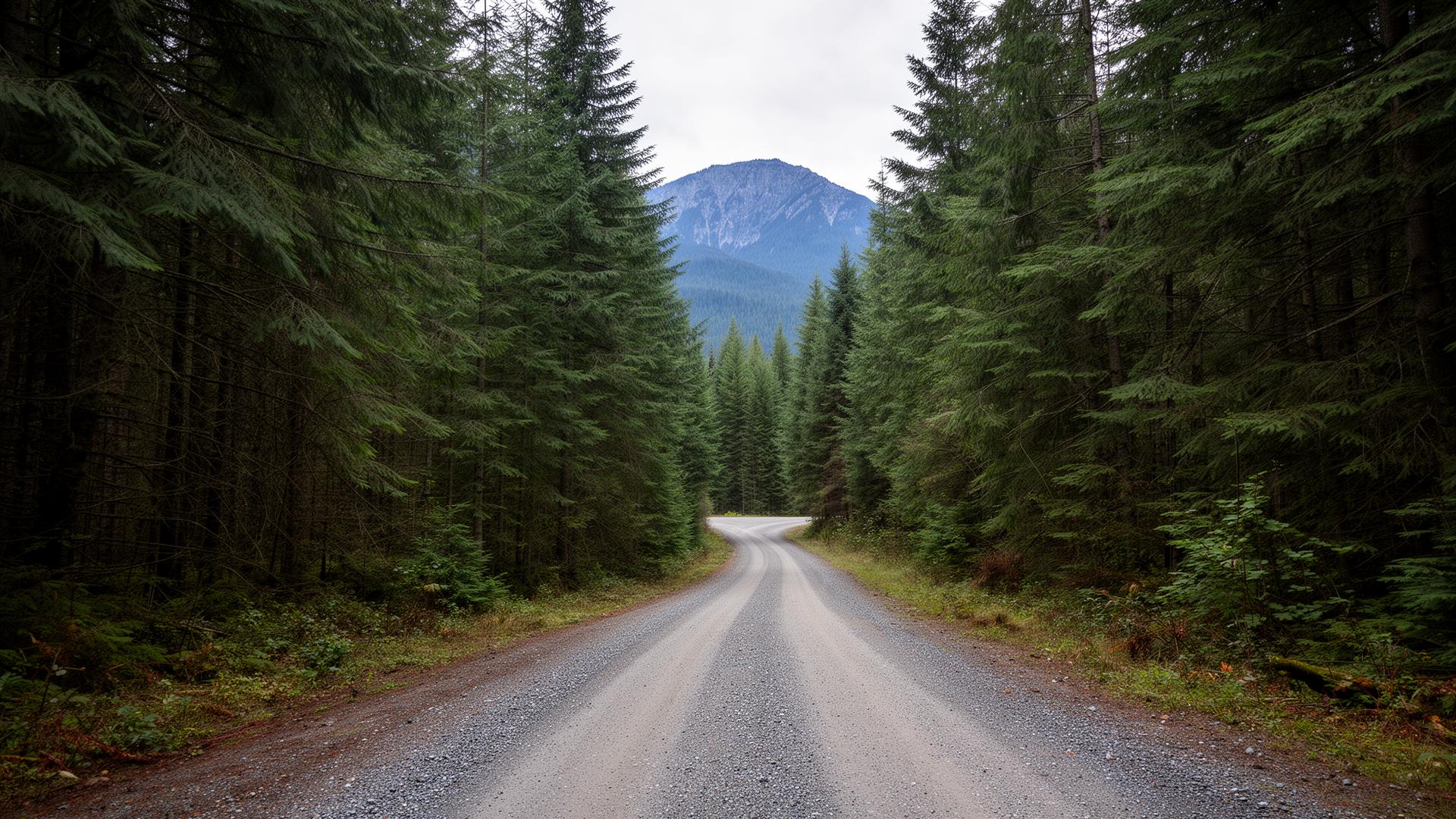
Let me be straight with you: Forest Service Roads are not Hwy 1 with gravel on them. They're industrial access roads that happen to be open to the public — and that distinction matters a lot when there's a loaded logging truck coming around a blind corner at 60 km/h.
I run these roads out of Chilliwack regularly. The terrain in our backyard — Chilliwack River Valley, Harrison East, Jones Lake, Sowaqua, Tamihi, Foley Creek — is genuinely spectacular and genuinely unforgiving if you're not prepared. This is what I've learned. Some of it the easy way.
Know What You're Actually Driving On
Forest Service Roads in British Columbia are administered by the BC government and maintained primarily by the forest industry under road permits, along with the gas, oil, and mining industries. They are not public highways. There are no guardrails, minimal signage, no cell service, and in most cases, you are sharing a single-lane road with 80,000 lb logging trucks.
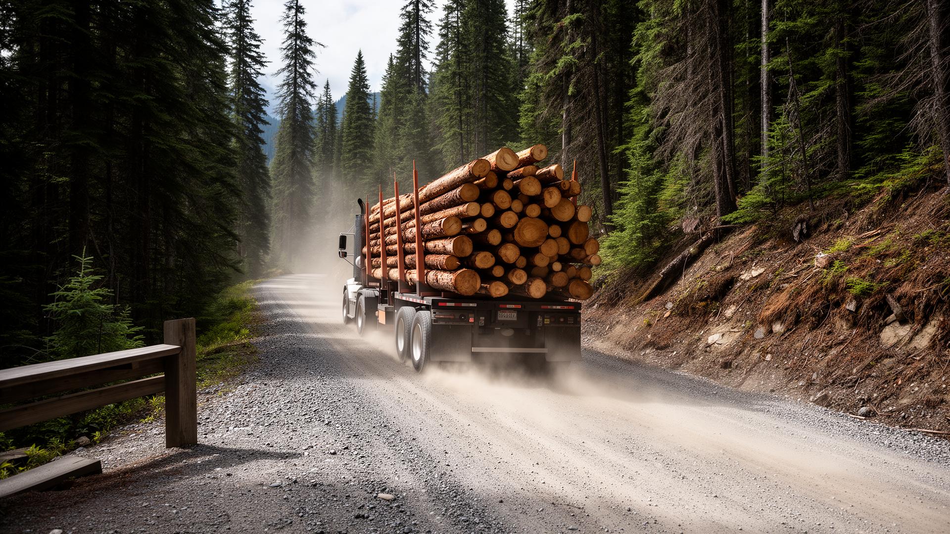
These roads are extremely active during the summer months and leave little room to get out of the way should you encounter a large logging truck — which always has the right of way.
That's not a suggestion. It's the rule. Internalize it before you leave the pavement.
Step One: Check Before You Leave
This is the most skipped step and the most important one.
The Chilliwack Natural Resource District maintains a live road closure and conditions page. Bookmark it. Check it the day before every trip.
- Chilliwack District FSR Closures: www2.gov.bc.ca — Chilliwack Natural Resource District road safety information
- BC Resource Road Safety (provincial): www2.gov.bc.ca — Resource road safety information
As a real-world example of why this matters: as of May 2026, Chilliwack Lake FSR, Jones Lake FSR, and Sowaqua FSR are all open — but American FSR is closed at 3.5 km and 5.0 km due to rockfall and road washout, Bench FSR is closed between 3.9 km and 13 km due to road washouts and unstable terrain, and Harrison East FSR has a "Rockfall Hazard — No Stopping" warning at 13.0 km.
Roads change fast after heavy rain, spring melt, and wildfire season. A Forest Service Road may be closed to vehicular access for safety or environmental reasons, and these closures may be temporary — check back regularly for updated information. There may also be instances where an event on a road or bridge has not yet been identified.
Apps and resources worth having:
- Backroad Mapbooks (app and paper) — the gold standard for BC FSR navigation, offline capable
- Gaia GPS — download tiles before you go, tracks your route
- BackroadStatus.com — community-reported road conditions
- BC Parks trail reports — useful for roads that access provincial parks
The Radio Situation (Read This Carefully)
This is where most recreational users are either confused or just ignoring the rules and hoping for the best.
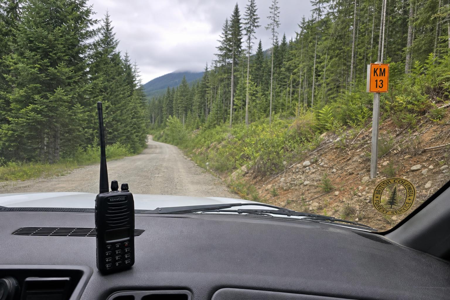
As of 2017, all BC forest districts use standardized two-way radio frequencies for drivers to communicate their location to other road users. Most resource roads are "radio assisted" rather than "radio controlled" — radios are recommended but not mandatory. Signs are posted at the start of the resource road with radio information.
In 2015, BC started rolling out the Resource Road Radio Program province-wide. The program created a common set of 35 road channels for use on public FSRs throughout the province, along with standardized protocol and signage. This allows FSR users to have their radios pre-loaded with all 35 channels and 14 "loading" channels, and easily switch to the appropriate one when entering an FSR.
How it works on the road: The protocol is to call out your position at every even kilometre marker travelling in, and every odd kilometre marker travelling out. For example: *"Northbound, passenger vehicle, kilometre 6, Chilliwack Lake Main."* This tells any truck coming the other way exactly where you are and what they're dealing with.
The legal reality: In accordance with the Radiocommunications Act, a mobile radio licence is required to operate on commercial land-mobile radios, such as those used on resource roads. The licence is available by submitting an application and a licence fee to ISED — approximately $42 annually — and only a qualified person or radio shop is allowed to program the channels.
Bottom line: Get a licensed VHF radio, have it programmed at a local radio shop, and use it. Driving FSRs without a radio in steep, single-lane terrain with blind corners puts you in a situation where a loaded logging truck cannot stop in time if they see you. The radio buys you time to pull into a pullout before the truck gets there. That's the whole point.
Right of Way: Not Negotiable
Down traffic has the right of way. Use the pullouts to move out of the way.
This is the primary rule of FSR driving. Loaded trucks coming downhill cannot stop — physics doesn't care about your schedule. When you hear a truck on the radio or see dust ahead, find the nearest pullout and get into it with room to spare. Don't stop on the road. Don't stop at a corner. Get completely clear.
Additional rules of the road:
- Headlights on at all times — required, not optional
- Speed to conditions — posted speeds are maximums under ideal conditions; fresh gravel, dust, mud, and shadows all demand less
- No passing on narrow sections — if you can't see 200 metres ahead, you don't pass
- Dust is a visibility hazard — back off from any vehicle ahead; the dust cloud they're generating is your enemy
Vehicle Prep: Honest Minimum Standards
You don't need a built-out overland rig to run most FSRs in the Chilliwack area. But you do need to be honest about your vehicle's limits and prepared for the reality that nobody is coming to rescue you quickly if something goes wrong.
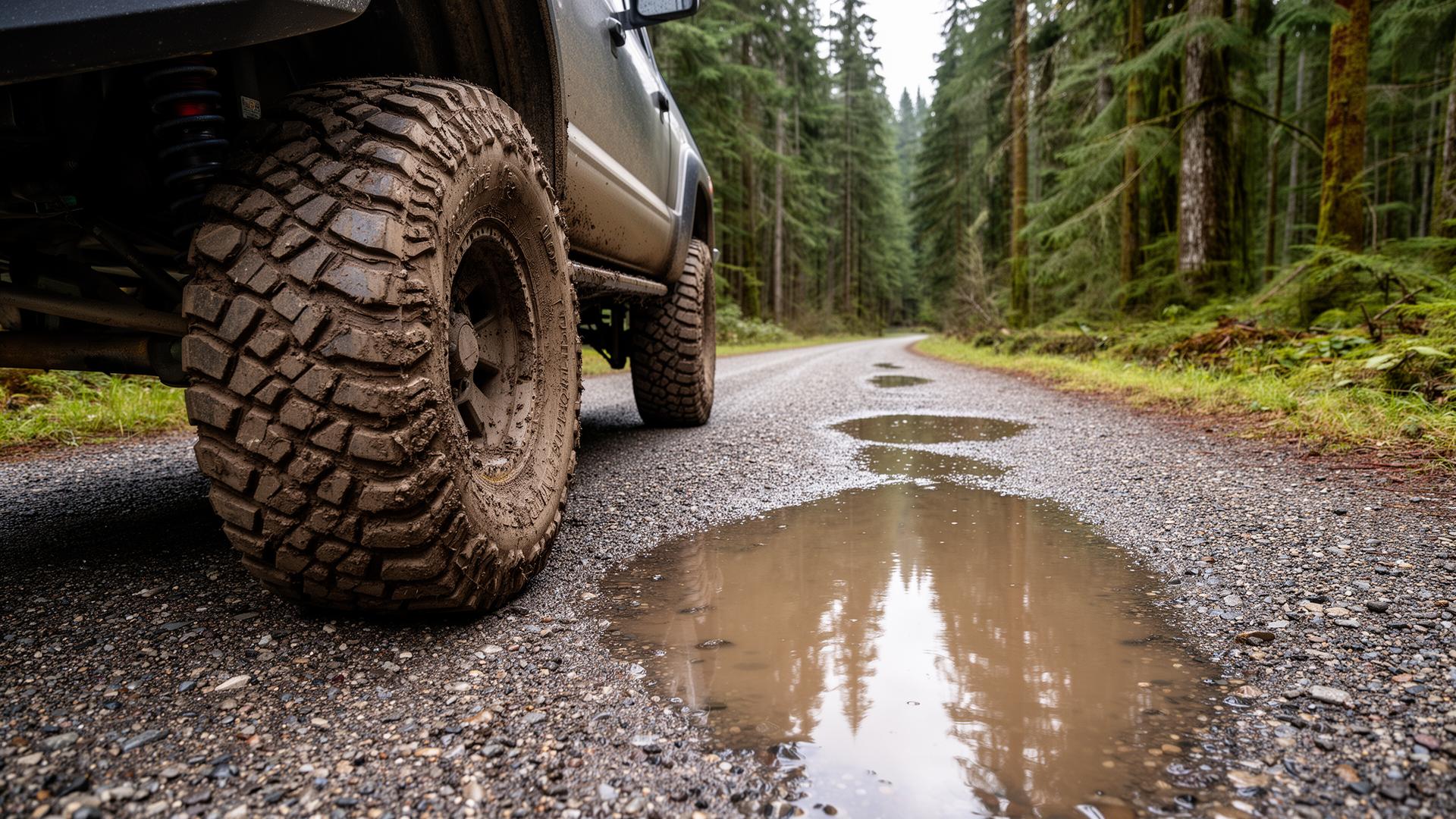
Tires matter most. All-terrain or mud-terrain tires are strongly recommended. All-season highway tires are a liability on wet clay grades and loose shale. Run slightly lower pressures on gravel (we run 15–20 psi in the Astro on FSR surfaces) for better traction and to reduce rock damage to sidewalls.
High clearance is real. Many Chilliwack FSRs — including the Chipmunk Creek FSR and Mount Cheam FSR — are described as requiring a high-clearance 4x4 vehicle as the roads are very rough. Know what your vehicle can clear before you commit to a road you can't turn around on.
Carry a spare — and know how to use it. Rock chips on FSR gravel are harder and sharper than highway gravel. Flat tires happen. One full-size spare minimum; two is smarter on longer trips.
Check the basics before every trip:
- Tire pressures and condition (including spare)
- Engine coolant level — grades are hard on cooling systems
- Brake fluid — you will be doing a lot of downhill braking
- Fuel — fill up before you leave pavement; there are no gas stations on FSRs
Communication: Your Lifeline
Once you're off pavement in the Chilliwack backcountry, your cell phone is a camera and a GPS. That's it. Rogers, Bell, Telus — zero coverage on most FSRs within 10 km of the valley floor.
Satellite communicators are not optional for remote trips. Devices like the Garmin inReach, Zoleo, SPOT, or ACR Bivy Stick let you send two-way SOS messages, share your location, message family, and trigger emergency response anywhere with a clear sky view.
The Garmin inReach Mini 2 is what I carry. Subscription is roughly $15–35/month depending on the plan. That's cheap insurance against a bad day becoming a deadly one.
Leave a trip plan with someone who will actually follow up. Tell them:
- Where you're going (specific FSR and destination)
- What vehicle you're driving
- When you expect to be out
- What to do if you haven't checked in by X time (call RCMP, not just wait)
Recovery Gear: The Non-Negotiable List
Getting stuck is a matter of when, not if — especially in spring and after rain. A solid recovery kit is non-negotiable for off-road travel.
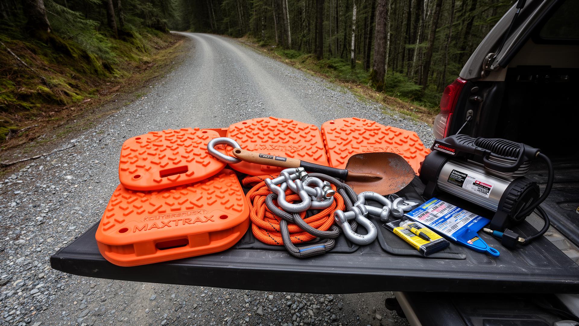
At minimum, you need traction boards to get out of mud, sand, or snow; recovery straps for pulling yourself or others out of trouble; a winch for serious pulling power; and a shovel for digging out.
For solo or two-vehicle travel in the Fraser Valley backcountry, carry at minimum:
- Traction boards (MAXTRAX or equivalent) — 2 boards minimum
- Snatch strap / kinetic recovery rope — 9m, 11,000 kg rating or higher
- Tree saver strap — to protect anchor points when winching
- D-shackles (x2 minimum, rated)
- Shovel — full-size, not a folding toy
- Hi-lift jack or air jack — standard scissor jacks are useless off-road
- Tire repair kit — plugs and a quality portable compressor (ARB or equivalent)
- Basic tool kit — sockets, screwdrivers, zip ties, electrical tape, duct tape, bailing wire
Seasonal Awareness for the Fraser Valley
The Chilliwack/Fraser Valley area has a specific seasonal pattern that directly affects FSR access and conditions.
Spring (April–June): Active logging season ramps up. Roads are soft from snowmelt. Bridges and culverts are under maximum stress. Mud is a real factor on north-facing slopes. Check closures obsessively — things change week to week.
Summer (July–August): Peak logging activity and peak recreational use. Dust is severe — your visibility behind a truck may be near zero. Wildfire closures can shut roads with no notice. Carry extra water.
Fall (September–October): The sweet spot. Logging activity often slows. Roads have dried and settled. Cooler temps. Best window for serious backcountry travel in this region.
Winter (November–March): Many FSRs are passable but require genuine winter capability — proper snow tires (not all-seasons), chains available, and honest assessment of your skill on icy grades. It is illegal to snowmobile on a plowed forest service road in BC, and early season access is a privilege that can be revoked if users abuse it.
Local Routes Worth Knowing
Here are some of the FSRs and access roads in the immediate Chilliwack area, ranging from mellow to committed:
Beginner-friendly / high-clearance recommended:
- Chilliwack Lake Road FSR — paved most of the way, transitions to gravel near the lake; great shakedown run
- Foley Creek FSR — easy, low-commitment route great for a shorter outing or early season while snow is still present at higher elevations; access to Chipmunk Caves and Foley Lake camping
- Jones Lake FSR — scenic, manageable, currently open (check for seasonal gate)
Intermediate / capable stock vehicle:
- Tamihi FSR — active logging road, rockfall warning at 3 km, radio strongly recommended
- Sowaqua FSR — currently open; mix of terrain leading to remote camping
- West Harrison FSR — leads toward Clear Creek Hot Springs; good mix of scenic views and more technical terrain
Advanced / high clearance 4x4 recommended:
- Mount Cheam FSR / Chipmunk Creek FSR — rough grades, serious terrain, reward is worth it
- American FSR — currently closed at 3.5 km; when open, requires real capability
The Stuff People Get Wrong
After years of running these roads, these are the mistakes I see repeatedly:
1. Not checking closures — showing up to a gated road is a wasted trip at best, dangerous at worst if you don't notice the closure 2. No radio — relying on luck on a blind corner isn't a strategy 3. Inadequate tires — highway all-seasons on wet clay grades are a liability 4. No trip plan filed — if you go in alone and something happens, nobody knows where to look 5. Camping at creek crossings — runoff from overnight rain can make a crossing that was knee-deep at 5 PM impassable at 5 AM 6. Not watching fuel — a detour adds up fast when you're getting 14 L/100 km on gravel grades 7. Underestimating time — FSR travel averages 30–40 km/h on a good day, less on rough sections; what looks like 50 km on a map can be 90 minutes of actual driving
Resources Summary
| Resource | What It's For | Link | |---|---|---| | Chilliwack NRD Closures | Live FSR closure info for this district | BC Gov — Chilliwack NRD | | BC Resource Road Safety (Provincial) | All-district closures and road safety info | BC Gov — Resource Roads | | BC Forest Safety Council | Road rules, radio program, safety videos | bcforestsafe.org | | Backroad Mapbooks | Best offline maps for BC backroads | backroadmapbooks.com | | Gaia GPS | Route tracking, offline topo maps | gaiagps.com | | BackroadStatus.com | Community road condition reports | backroadstatus.com | | ISED Mobile Radio Licence | Required for FSR VHF radio operation | ised-isde.canada.ca |
Final Word
The roads out of Chilliwack into the Coast Mountains and the Fraser Valley backcountry are some of the best access to remote terrain anywhere in BC. The Chilliwack River Valley, Harrison country, Sowaqua drainage — this is world-class wilderness that happens to be 30 minutes from the Trans-Canada.
That access is a privilege, not a right. It exists because the forestry industry built and maintains these roads, and recreational users are guests on them. Behave accordingly — use your radio, yield to trucks, pack out your garbage, and don't block active industrial access.
Go prepared, go informed, and go humble about what your rig can actually do. The mountains will still be there next weekend if you turn around today.
Share this post
Comments
Loading comments…